


Physical Features Of India Questions and Answers - Free PDF Download
Class 9 Geography Chapter 2, Physical Features of India, explains the major landforms of the country, including the Himalayas, Northern Plains, Peninsular Plateau, Coastal Plains, and Islands. These physical features play an important role in shaping India’s climate, natural resources, and human activities. The Physical Features of India Class 9 questions and answers are prepared according to the NCERT textbook and present concepts in a clear and structured manner. These NCERT solutions for Class 9 Social Science Geography Chapter 2 help students understand key geographical ideas with accuracy and clarity. Students can also download the Physical Features of India Class 9 PDF for easy access. All Geography Class 9 Chapter 2 question answer sets are prepared by Vedantu experts and aligned with the latest CBSE Class 9 Social Science syllabus.
 Table of Content
NCERT Solutions For Class 9 Social Science Geography Contemporary India Chapter 2 Physical Features Of India (2025-26)
1. Choose the right answer from the four alternatives given below.
(i). A landmass bounded by sea on three sides is referred to as
Coast
Island
Peninsula
None of the above
Ans. (c) Peninsula
(ii). Mountain ranges in the eastern part of India forming its boundary with Myanmar are collectively called as
Himachal
Uttarakhand
Purvanchal
none of the above
Ans. (c) Purvanchal
(iii). The western coastal strip, south of Goa is referred to as
Coromandel
Konkan
Kannad
Northern Circars
Ans. (b) Kannad
(iv). The highest peak in the Eastern Ghats is
Anai Mudi
Kanchenjunga
Mahendragiri
Khasi
Ans: (c) Mahendragiri
2. Answer the following questions briefly.
(i). What is bhabar?
Ans: Bhabar is a narrow belt containing pebbles instead of silt along the banks of the upper Himalayan rivers from the Indus river to the Teesta River.
(ii). Name the three major divisions of the Himalayas from north to south.
Ans: The three major divisions of the Himalayas are:
The Great or the Inner Himalayas or the Himadri
The Middle Himalayas or the Himachal
The Outer Himalayas or the Shivaliks
(iii). Which plateau lies between the Aravali and the Vindhyan ranges?
Ans. The Malwa plateau lies between the Aravali and the Vindhyan Ranges.
(iv). Name the island group of India having coral origin.
Ans. Lakshadweep Islands is the island group of Indiawhich has a coral origin.
3. Distinguish between:
(i). Bhangar and Khadar
Ans: The difference between Bhangar and Khadar soils are:
(ii). Western Ghats and Eastern Ghats
Ans. The difference between the Western Ghats and the Eastern Ghats are:
4. Which are the major physiographic divisions of India? Contrast the relief of the Himalayan region with that of the Peninsular plateau.
Ans: The major physiographic divisions of India are:
The Himalayan Mountains
The Northern Plains
The Peninsular Plateau
The Indian Desert
The Coastal Plains
The Islands
5. Give an account of the Northern Plains of India.
Ans: The Northern Plains are formed by the deposition of the fertile alluvium that was deposited by the rivers originating in the Himalayas. They stretch from the south of the northern mountains to the north of the peninsular plateau and towards the east of the Indian desert. It is divided into three parts, i.e. Punjab Plains, Ganga Plains and the Brahmaputra Plains. The Northern plains cover approximately 3000 kilometers and there are several rivers that drain this region such as Sutlej, Ravi, Beas, Ganga, Yamuna, Ghagra, Gandak, Kosi, Chambal, Betwa, Son, etc.
The North Indian Plains are divided into four different zones:
Bhabhar
Tarai
Bangar
Khadar
6. Write short notes on the following.
(i). The Indian Desert
Ans: The Great Indian Desert is also known as the Thar Desert and is located in Rajasthan, India and also in Punjab and Sindh in Pakistan. A part of the desert is also located in the states of Gujarat and Haryana.
The Thar desert is a very dry region in between the countries of India and Pakistan and is highly scarce in water availability and the only water sources are the natural and man-made ponds across the region. Due to this reason, the people generally live a nomadic life, which involves their constant movement from place to place. The Luni river is an important river in the Thar desert and it drains a large area of the desert. The other major river is Ghaggar which flows in the northern and eastern part of the desert.
(ii). The Central Highlands
Ans: The parts of the peninsular plateau which are found in the north of the River Narmada and generally covers a major portion of the Malwa plateau is known as the Central Highlands. The rivers which drain this region flow from southwest to northeast, due to their slope. The Central Highlands are wider in the western side but narrow down towards the east. In Madhya Pradesh, Uttar Pradesh and Chhattisgarh, they are known as Bundelkhand and Baghelkhad. The Chotanagpur plateau is in the extreme east of the Central Highlands with the the Damodar River flowing through it.
(iii). The Island groups of India
Ans: There are two island groups controlled by India. They are located in the Arabian Sea (Lakshadweep Islands) and the Bay of Bengal (Andaman and Nicobar Islands). These islands are located off the Malabar coast of India. The capital city of Lakshadweep Islands is Kavaratti and is the smallest Union territory by area and the second smallest by population. The Islands of Lakshadweep provide India a strategic base in the Arabian Sea and India is able to reach out to the Maldives and other regions in the Indian Ocean in crucial times.
The Andaman and Nicobar Islands are a group of 572 islands. The Nicobar Islands extend close to the Sumatra islands which make the reach of India to Southeast Asian nations very easy, The Indian Navy also maintains a base in the Andaman and Nicobar Islands which helps it to control the vessels passing through the strait of Malacca. The Andaman and Nicobar Islands also have the North Sentinel Island which has the most primitive people from the human race and are untouched by civilization and they are known as the Sentinelese people.
Map Skills:
On an outline map of India show the following.
i. Mountain and hill ranges – the Karakoram, the Zaskar, the Patkai Bum, the Jaintia, the Vindhya range, the Aravali, and the Cardamom hills.
ii. Peaks – K2, Kanchenjunga, Nanga Parbat and the Anai Mudi.
iii. Plateaus, Chotanagpur and Malwa
iv. The Indian Desert, Western Ghats, Lakshadweep Islands
Ans:
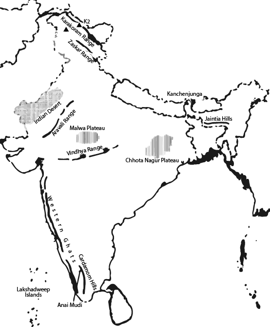
Map
Topics Covered in Class 9th Geography Chapter 2: Physical Features of India
Benefits of Referring to Class 9 Geography Chapter 2 Questions and Answers
Ch 2 Geography Class 9 helps students understand the diverse physical features of India, such as mountains, plains, rivers, and coastlines enabling them to solve the questions properly.
Physical Features Of India Class 9 provides a detailed exploration of India's diverse physical features, including mountains, etc ensuring the comprehensive concepts are clear.
Physical Features Of India Class 9 improves map reading skills as students learn to identify and locate major physical features of India on maps, which is crucial for both exams and practical understanding.
Class 9 Chapter 2 Geography promotes awareness about environmental issues enabling critical thinking.
NCERT Class 9 Geography Chapter 2 is aligned with the updated CBSE syllabus, ensuring that students cover the topics and concepts required for the present academic year.
Students can also check and refer to Class 9 Physical Features Of India Revision Notes and Physical Features Of India Important Questions to learn effectively for their exams.
Conclusion
NCERT Class 9 Geography Chapter 2 "Physical Features of India" provides a clear and detailed understanding of India's diverse landscapes, including mountains, plateaus, plains, and coastal areas. Class 9th Geography Chapter 2 Question Answer helps students grasp the significance of each physical feature and their impact on the climate, natural resources, and human activities. Understanding the Class 9 Geography Chapter 2 Question Answer is crucial for a solid foundation in geography. These questions often cover the identification and explanation of different physical features, their importance, and their influence on human life and the environment. Overall, Vedantu’s NCERT Solutions make studying this chapter easier, helping students to prepare effectively for their exams by focusing on important topics and practising relevant questions.
NCERT Solutions for Class 9 Geography Other Chapter-Wise Links - Download the FREE PDF
Related Important Links for Class 9 Social Science Geography


FAQs on NCERT Solutions For Class 9 Social Science Geography Contemporary India Chapter 2 Physical Features Of India (2025-26)
1. What does Class 9 Geography Chapter 2 Physical Features of India explain in NCERT?
Class 9 Geography Chapter 2 – Physical Features of India explains the major landforms of the country, such as the Himalayan Mountains, Northern Plains, Peninsular Plateau, Indian Desert, Coastal Plains, and Islands. On Vedantu, NCERT Solutions explain these features exactly as described in the NCERT textbook.
2. What types of questions can students expect from Physical Features of India Class 9?
From physical features of India Class 9, students can expect descriptive questions, short notes, and comparison-based questions related to India’s physiographic divisions. Vedantu’s NCERT Solutions help students understand how such textbook questions are answered as per NCERT standards.
3. Are Physical Features of India Class 9 questions and answers strictly NCERT-based?
Yes, physical features of India Class 9 questions and answers available on Vedantu are fully based on the NCERT textbook. The answers follow NCERT definitions, maps, and explanations without adding extra reference material.
4. Which physiographic divisions are covered in Class 9 Geography Chapter 2?
Class 9 Geography Chapter 2 covers six major physiographic divisions of India:
The Himalayan Mountains
The Northern Plains
The Peninsular Plateau
The Indian Desert
The Coastal Plains
The Islands
All these topics are clearly explained in Vedantu’s NCERT Solutions.
5. How do NCERT Solutions help in answering Geography Class 9 Chapter 2 questions?
Geography Class 9 Chapter 2 question answers help students learn how to write clear, structured answers using NCERT language. On Vedantu, solutions follow the textbook approach, which is useful for CBSE exam preparation.
6. Do Vedantu’s NCERT Solutions include all exercise questions of Chapter 2?
Yes, Vedantu’s NCERT Solutions for Class 9 Social Science Geography Chapter 2 include complete answers to all in-text and exercise questions given in the NCERT textbook, without skipping any question.
7. How are terms like bhabar and plains explained in NCERT Solutions?
In Class 9 Geography Chapter 2, terms such as bhabar, plains, plateaus, and deserts are explained clearly using NCERT descriptions. Vedantu presents these explanations in a student-friendly manner while staying textbook-focused.
8. Are NCERT Solutions enough for Class 9 Geography Chapter 2 exam preparation?
Yes, practising NCERT Solutions for Class 9 Geography Chapter 2 on Vedantu is sufficient for school exams, as CBSE questions are framed directly from the NCERT textbook.