


Drainage Questions and Answers for Class 9 Students
This free PDF download provides questions and answers for NCERT Class 9 Geography, Chapter 3, "Drainage." The chapter covers the major river systems in India, such as the Ganga, Brahmaputra, and Indus, along with their importance in agriculture and their challenges. Class 9 Geography Chapter 3 NCERT Solutions help you understand these topics clearly, cover all essential points, and prepare effectively for exams. Enhance your studies with Class 9 Geography NCERT Solutions and gain deeper insights into environmental concepts.
 Table of Content
By accessing Class 9 Geography Chapter 3 questions and answers, students gain comprehensive insights into the core concepts, such as the drainage system, river patterns, watershed management, and more, as outlined in the curriculum. Download the PDF for easy access to these useful resources. Check out the revised class 9 social science syllabus along with the NCERT Solutions PDF, and start with Vedantu to embark on a journey of academic excellence.
Glance on NCERT Solutions for Class 9 Geography (Contemporary India) Chapter 3 Drainage
Class 9th Geography Chapter 3 Drainage explores the drainage system in India, focusing on the river systems and their significance.
This Chapter teaches about India's major river systems, including the Himalayan rivers (Indus, Ganga, Brahmaputra) and the Peninsular rivers (Godavari, Krishna, Kaveri, Narmada, Tapi).
Understand drainage patterns like dendritic, trellis, radial, and rectangular.
Study the concept of river basins and the importance of watershed management.
Chapter 3 Drainage Class 9 discusses various types of lakes, their formation processes, and their ecological and economic importance.
Utilisation of maps and diagrams to illustrate the courses of major rivers, their tributaries, and drainage patterns, aiding visual learning and retention.
Geography class 9, chapter 3 explores issues related to river pollution and the measures taken for water conservation.
Drainage class 9 discusses the importance of rivers in agriculture, transportation, and as a water source for domestic and industrial use.
Utilise maps to identify and understand the course of major rivers and their tributaries in Chapter 3, Geography class 9.
NCERT Class 9 Geography Chapter 3 helps students appreciate the role of rivers and lakes in India's geographical and economic landscape.
1. Choose the right answer from the four alternatives given below.
i). In which of the following states is the Wular lake located?
Rajasthan
Uttar Pradesh
Punjab
Jammu and Kashmir
Ans. (d) Jammu and Kashmir
ii). The river Narmada has its source at
Satpura
Brahmagiri
Amarkantak
Slopes of the Western Ghats
Ans. (c) Amarkantak
iii). Which one of the following lakes is a salt water lake?
Sambhar
Dal
Wular
Gobind Sagar
Ans. (a) Sambhar
iv). Which one of the following is the longest river of the Peninsular India?
Narmada
Krishna
Godavari
Mahanadi
Ans. (c) Godavari
v). Which one amongst the following rivers flows through a rift valley?
Mahanadi
Tungabhadra
Krishna
Tapi
Ans. (d) Tapi
2. Answer the following questions briefly.
i). What is meant by a water divide? Give an example.
Ans. A mountain range or a hill separating two different drainage basins is called a water divide. For example, Western Ghats.
ii). Which is the largest river basin in India?
Ans. The Ganga river basin is the largest river basin in India.
iii). Where do the rivers Indus and Ganga have their origin?
Ans. The Indus river has its origins in Tibet near the Mansarovar Lake while the Ganga River has its origins in the Gangotri Glacier in Uttarakhand state.
iv). Name the two headstreams of the Ganga. Where do they meet to form the Ganga?
Ans. Alaknanda and Bhagirathi are the two headstreams of the Ganga. They both meet to form the Ganga at Devprayag.
v). Why does the Brahmaputra in its Tibetan part have less silt, despite a longer course?
Ans. The Brahmaputra river also known as Tsangpo in Tibet receives very little volume of water in Tibet so it carries little silt there. But once it enters into India from Arunachal Pradesh, it is fed by lots of rains and hence carries lots of water and silt.
vi). Which two Peninsular rivers flow through trough?
Ans. The two rivers that flow through troughs in India are Narmada and Tapi. They form estuaries while entering the sea unlike deltas.
vii). State some economic benefits of rivers and lakes.
Ans. Rivers are very beneficial for agricultural purposes and generating hydro- electricity. They also provide fisheries and inland channels for transportation. The lakes like the Sambhar Lake provide edible salts to people. They also help to develop tourism and provide recreation for people such as Panging Tso.
3. Below are given names of a few lakes of India. Group them under two categories – Natural and created by human beings.
Wular
Dal
Nainital
Bhimtal
Gobind Sagar
Loktak
Barapani
Chilika
Sambhar
Rana Pratap Sagar
Nizam Sagar
Pulicat
Nagarjuna Sagar
Hirakud
Ans. The Natural Lakes are: Wular, Dal, Nainital, Bhimtal, Chilika, Pulicat, Sambhar, Barapani, Loktak.
The Lakes created by human beings are: Gobind Sagar, Hirakud, Rana Pratap Sagar, Nagarjuna Sagar, Nizam Sagar.
4. Discuss the significant difference between the Himalayan and the Peninsular rivers.
Ans. The following is the comparison of the two rivers:
5. Compare the east flowing and the west flowing rivers of the Peninsular plateau.
Ans. The following is the comparison of the two rivers:
6. Why are rivers important for the country’s economy?
Ans. The rivers important for the any country’s economy because:
They are a source of natural fresh water which is required for the survival of all living beings.
The rivers provide water for various purposes as well as act as important trade routes within the country.
They also serve as a source of potential energy using hydro power.
It is also used for navigation and transportation and is important for commercial activities.
It also provides great scenic and recreational values for tourism. Thus, they serve as good tourist spots in the state.
(i) On an outline map of India mark and label the following rivers: Ganga, Satluj, Damodar, Krishna, Narmada, Tapi, Mahanadi, and Brahmaputra.
(ii) On an outline map of India mark and label the following lakes: Chilika Sambhar, Wular, Pulicat, Kolleru.
Ans:
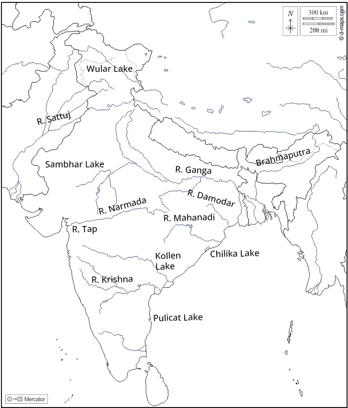
Outline Map of India mark Lakes
Topics Covered In Class 9 Geography Chapter 3 Drainage
Benefits of NCERT Solutions for Class 9 Social Science Drainage Chapter 3
The NCERT solutions provide detailed explanations of India's drainage system, helping students grasp the complexity of river systems, drainage patterns, and their significance.
All the concepts in drainage class 9 question answers are explained in simple language combined with diagrams, discussions, maps, etc, wherever needed.
The solutions provide a clear and comprehensive understanding of the chapter's content, aiding in effective exam preparation.
By breaking down intricate topics such as river basins, watershed management, and different types of lakes, the solutions ensure that students clearly understand key geographical concepts.
The geography class 9 chapter 3 solutions include maps and diagrams that aid visual learning, making it easier for students to visualise the courses of rivers, their tributaries, and various drainage patterns.
By explaining the geographical significance of rivers and lakes in drainage class 9, the solutions help students understand the real-world impact of these water bodies on agriculture, transportation, and human settlements.
Vedantu offers the best NCERT Solutions chapter 3 Geography class 9, providing comprehensive support for students' self-study needs.
For better preparation, you can refer to Vedantu’s additional study materials, like Revision Notes for Class 9 Drainage, and Important Questions for Class 9 Drainage along with the NCERT Solutions.
Conclusion
NCERT Solutions for Class 9 Geography Chapter 3, "Drainage," offers a comprehensive and in-depth understanding of India's intricate drainage system. These solutions provide detailed explanations of key concepts such as river systems, drainage patterns, and watershed management, making complex topics accessible and understandable for students. Students can rely on Vedantu's NCERT Solutions to enhance their knowledge, clarify doubts, and confidently prepare for exams.
Important Study Material Links for Class 9 Geography Chapter 1
NCERT Solutions for Class 9 Geography - Other Chapter-wise Links for FREE PDF
Dive into our FREE PDF links, which offer chapter-wise NCERT solutions prepared by Vedantu Experts to help you understand and master social concepts.
Related Important Links for Class 9 Geography (Contemporary India)


FAQs on NCERT Solutions For Class 9 Social Science Contemporary India Chapter 3 Drainage - 2025-26
1. What topics are covered in Vedantu's NCERT Solutions for Class 9 Geography Chapter 3, Drainage?
These NCERT Solutions provide step-by-step answers for all the exercise questions in Chapter 3, Drainage. The key topics covered include India's major river systems (both Himalayan and Peninsular), different drainage patterns, the concept of a water divide, the formation and importance of lakes, the role of rivers in the economy, and the causes and effects of river pollution.
2. How do these NCERT Solutions help in solving the map-based questions for the Drainage chapter?
The solutions provide clear guidance for the map-pointing tasks in the NCERT textbook. They help you accurately identify and mark major rivers like the Ganga, Brahmaputra, Narmada, and Godavari, as well as significant lakes such as Wular, Chilika, and Pulicat. Following these solutions ensures you learn the correct locations as per the CBSE curriculum.
3. How do the NCERT Solutions for Chapter 3 explain the main differences between Himalayan and Peninsular rivers?
The solutions provide a clear, point-wise comparison to help you answer this question effectively. They explain that:
- Origin: Himalayan rivers originate from snow-clad mountains and are perennial, while Peninsular rivers are mostly rain-fed and seasonal.
- Course: Himalayan rivers have long, meandering courses and form large deltas, whereas Peninsular rivers have shorter, straighter courses and often form estuaries.
- Basins: The solutions clarify that Himalayan rivers have larger drainage basins compared to their Peninsular counterparts.
4. Why is a step-by-step answering method, as shown in the solutions, important for explaining different drainage patterns?
A step-by-step method is crucial because drainage patterns are a direct result of the region's topography and rock structure. The solutions break down the logic for each pattern:
- Dendritic: Explained as a tree-branch-like pattern that develops on gentle slopes with uniform rock types.
- Trellis: Shown to form where hard and soft rocks exist parallel to each other.
- Radial: Clarified as a pattern where streams flow in different directions from a central peak, like a dome.
5. What is the correct way to define a 'water divide' as per the NCERT exercise questions?
According to the solutions for the NCERT exercises, a water divide is defined as any elevated area, such as a mountain or an upland, that separates two distinct drainage basins. The solutions explain that water flowing on one side of the divide enters one river system, while water on the other side flows into another, helping to clearly demarcate the catchment areas of different rivers.
6. Beyond just listing facts, how do the NCERT solutions help in comparing the economic importance of rivers versus lakes?
The solutions guide you to form a comparative analysis. While both are important, the answers highlight their distinct roles:
- Rivers are crucial for generating hydroelectricity, large-scale irrigation through canals, and inland navigation, forming the backbone of agricultural economies.
- Lakes are vital for regulating river flow, moderating climate, preserving aquatic ecosystems, and promoting tourism. The solutions help you structure an answer that compares these unique contributions rather than just stating them separately.
7. Are the NCERT Solutions for Class 9 Geography Chapter 3 updated for the 2025-26 CBSE session?
Yes, all NCERT Solutions provided by Vedantu, including those for Class 9 Geography Chapter 3 (Drainage), are meticulously prepared by subject experts to align with the latest CBSE guidelines and syllabus for the 2025-26 academic year. This ensures the answers are accurate, relevant, and follow the current curriculum standards.
8. While solving questions on river pollution, what common mistakes do these NCERT solutions help students avoid?
Students often list causes of pollution without explaining the impact. These solutions help you avoid this by structuring answers that connect cause and effect. For example, they clarify how industrial effluents lead to the death of aquatic life, and how untreated domestic sewage increases biochemical oxygen demand (BOD), making the water unfit for use. This ensures a comprehensive and scientifically accurate answer.
9. How do the NCERT solutions for this chapter explain the formation of different types of lakes in India?
The solutions provide clear explanations for the formation of various lakes as asked in the textbook exercises. They describe how oxbow lakes are formed by meandering rivers, how lagoons like Chilika are formed by coastal deposition, and how glacial lakes are a result of glacier movement. For each type, the solutions offer a concise definition and a relevant example, making the concept easy to understand and remember.
10. How does solving the NCERT questions for the Drainage chapter help in understanding other Social Science topics?
Mastering the concepts in this chapter through the NCERT solutions provides a strong foundation for other topics. Understanding river systems is essential for studying India's climate (Chapter 4), as rivers influence weather patterns. It is also directly linked to agriculture and the economy, as river plains are the most fertile and densely populated regions. The solutions help build these crucial inter-disciplinary connections.