


Class 11 Geography Chapter 6 Natural Hazards and Disasters Important Questions with Answers PDF
Practise 28 important questions covering India's disaster-prone regions, different types of hazards, their environmental and social impacts, and methods of risk reduction. The set includes 6 MCQs, 5 very short answers, 8 short answers and 9 long answers, including questions based on the chapter's hazard-zone maps.
Class 11 Geography Chapter 6 MCQs with Answers
Q1. A river overflows in an uninhabited region without causing serious damage. When would the same natural event be considered a disaster?
(a) Whenever the river changes direction
(b) When it causes widespread damage and serious disruption to people and property (c) Whenever rainfall exceeds the annual average
(d) Only when an earthquake occurs at the same time
Answer: (b) When it causes widespread damage and serious disruption to people and property.
Explanation: A natural hazard can cause harm. It becomes a disaster when its effects cause serious losses or disruption that exceed the affected community's normal capacity to cope.
Q2. Which of the following is classified as a biological natural hazard in Table 6.1?
(a) Earthquake
(b) Tsunami
(c) Locust infestation
(d) Tropical cyclone
Answer: (c) Locust infestation.
Explanation: Natural disasters are classified into atmospheric, terrestrial, aquatic and biological categories. Locust infestations and certain disease outbreaks belong to the biological category.
Q3. Why are the Himalayas and northeastern India particularly vulnerable to tectonic earthquakes?
(a) They are located away from all plate boundaries.
(b) The Indian and Eurasian plates interact in this region.
(c) The region receives no rainfall.
(d) The rocks are entirely volcanic.
Answer: (b) The Indian and Eurasian plates interact in this region.
Explanation: The Indian Plate moves towards the Eurasian Plate. Stress builds up as the plates interact, and sudden energy release can cause destructive earthquakes.
Q4. A coastal settlement experiences an abnormal rise in sea level during a severe tropical cyclone. What is this phenomenon called?
(a) Agricultural drought
(b) Storm surge
(c) Soil liquefaction
(d) River capture
Answer: (b) Storm surge.
Explanation: A storm surge is an abnormal rise in sea level associated with cyclone winds and pressure conditions. It can inundate coastal settlements, roads and agricultural fields.
Q5. Which form of drought occurs when the moisture available in the soil becomes insufficient for crop growth?
(a) Hydrological drought
(b) Agricultural drought
(c) Ecological drought
(d) Coastal drought
Answer: (b) Agricultural drought.
Explanation: Agricultural drought, also called soil-moisture drought, occurs when the soil does not contain enough water to support crops, sometimes resulting in crop failure.
Q6. According to the chapter exercises, the Malpa landslide occurred in which district of Uttarakhand?
(a) Almora
(b) Bageshwar
(c) Pithoragarh
(d) Champawat
Answer: (c) Pithoragarh.
Explanation: Malpa, in Pithoragarh district, is discussed in the chapter's exercises as an example of a landslide disaster in the Himalayan region.
Class 11 Geography Chapter 6 Very Short Answer Questions
Q7. What is the difference between a natural hazard and a natural disaster?
Answer: A natural hazard is an environmental condition or event that can potentially cause harm. A natural disaster occurs when that event causes serious losses, widespread damage or major disruption to human life and property.
Q8. Name the four main categories of natural disasters given in Table 6.1.
Answer: Atmospheric, terrestrial, aquatic and biological disasters.
Q9. What is liquefaction during an earthquake?
Answer: Liquefaction occurs when saturated soil temporarily loses strength during strong shaking and behaves more like a liquid. Buildings and other structures may tilt, settle or become unstable.
Q10. What is a tsunami?
Answer: A tsunami is a series of long ocean waves usually caused by sudden displacement of seawater following an undersea earthquake, volcanic eruption or similar disturbance.
Q11. What is meant by vulnerability in disaster management?
Answer: Vulnerability refers to how susceptible people, buildings, infrastructure or communities are to harm when a natural hazard occurs. It depends on physical, social, economic and environmental conditions.
Class 11 Geography Chapter 6 Short Answer Questions
Q12. Distinguish between atmospheric, terrestrial, aquatic and biological disasters with suitable examples.
Answer: Table 6.1 groups natural disasters according to their main environmental origin or characteristics.
Explanation: Classification helps identify the causes of disasters and select suitable prevention, preparedness and mitigation measures.
Q13. Why can deforestation, unplanned construction and floodplain encroachment turn natural hazards into more destructive disasters?
Answer: Human activities can increase the vulnerability of an area even when they do not directly cause the original natural event.
Deforestation: Removing vegetation can increase surface runoff and weaken slope stability.
Floodplain Encroachment: Houses and buildings constructed close to rivers are more exposed to flooding.
Unplanned Road Construction: Cutting steep slopes without proper support can increase landslide risk.
Blocked Drainage: Construction and waste can obstruct natural water channels and worsen flooding.
Coastal Development: Dense settlement close to the shoreline increases exposure to cyclones and tsunamis.
Conclusion: A natural hazard becomes more damaging when human activities increase exposure or reduce the environment's ability to withstand its effects.
Q14. Study Figure 6.2 – India: Earthquake Hazard Zones. Which regions are particularly vulnerable to earthquakes, and why?
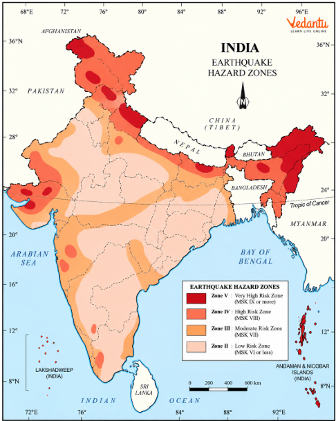
(a) Which major mountain region is highly vulnerable to earthquakes?
Answer: The Himalayan region.
(b) Why is northeastern India earthquake-prone?
Answer: The region is influenced by active tectonic processes associated with the Indian Plate and adjoining plate-boundary systems.
(c) Why is the Kachchh region important when studying earthquake hazards?
Answer: The Kachchh region of Gujarat has experienced destructive earthquakes, including the 2001 Bhuj earthquake, demonstrating that damaging earthquakes can occur away from the Himalayan belt.
(d) Does lower earthquake risk mean an area is completely earthquake-free?
Answer: No. Lower-hazard zones are relatively less susceptible, but earthquakes can still occur.
(e) How can an earthquake hazard map help planners?
Answer: It helps identify regions where earthquake-resistant construction, public preparedness and monitoring should receive greater attention.
Q15. Why can earthquakes in mountainous regions trigger landslides, river blockages and floods?
Answer: Earthquakes can produce several connected environmental effects.
Strong ground shaking destabilises slopes.
Rocks, debris and soil may move downhill as landslides.
Falling material can block roads, railway lines and river channels.
Blocked rivers may temporarily form lakes behind accumulated debris.
If such a blockage fails, water may rush downstream and cause flooding.
Ground deformation can also change drainage routes and damage infrastructure.
Conclusion: Earthquake damage is not limited to ground shaking. Secondary events such as landslides and flooding can increase the overall destruction.
Q16. How are tsunamis different from ordinary sea waves, and why do they become dangerous near coasts?
Answer: Tsunamis differ from ordinary wind-generated sea waves in their origin and movement.
Explanation: As a tsunami approaches shallow coastal water, its speed decreases, and its wavelength shortens. Its height can increase significantly, producing destructive flooding.
Q17. Why are floods common in Assam and Bihar, while flash floods may occur in Rajasthan and Gujarat?
Answer: Flooding occurs in both eastern and western India, but the geographical circumstances differ.
Eastern India: Rivers such as the Brahmaputra and those draining the Himalayan catchments carry large volumes of monsoon water and sediment. Flooding can spread across extensive low-lying plains.
Western India: Short periods of intense rainfall can generate sudden runoff in normally dry areas. Obstructed drainage channels and construction in natural watercourses can worsen flash floods.
Conclusion: Flood vulnerability depends on rainfall intensity, river systems, terrain and human land use.
Q18. Explain meteorological, agricultural, hydrological and ecological drought with one example of each.
Answer: Four types of drought are recognised according to the kind of water shortage and its effects.
Conclusion: Drought is not only a shortage of rainfall. Its consequences can extend to agriculture, water storage and natural ecosystems.
Q19. Why are some Himalayan and Western Ghats slopes more vulnerable to landslides than stable plateau regions?
Answer: Landslide vulnerability depends on geological structure, slope, rainfall, vegetation and human activities.
Steep Slopes: Material is more likely to move downhill on steep terrain.
Young Mountains: Parts of the Himalayas contain unstable geological structures.
Heavy Rainfall: Water can saturate soil and weaken slope stability.
Earthquake Shaking: Ground motion may loosen rocks and soil.
Road Construction: Cutting into slopes can remove natural support.
Vegetation Loss: Removing trees reduces some of the natural reinforcement provided by roots.
Local Differences: Stable, gently sloping areas generally face lower landslide vulnerability than unstable mountain slopes.
Conclusion: Landslide risk is especially high where steep terrain and unstable geology combine with heavy rainfall or poorly planned human activity.
Class 11 Geography Chapter 6 Long Answer Questions
Q20. Explain why earthquakes are frequent in the Himalayan region. Describe their major consequences and methods of mitigation.
Answer: The Himalayan region is one of India's most important earthquake-prone areas because of continuing tectonic activity.
Causes of Himalayan Earthquakes
Movement of the Indian Plate: The Indian Plate continues to move towards the Eurasian Plate.
Plate Interaction: The movement is resisted along the Himalayan collision zone.
Accumulation of Stress: Stress builds up in rocks along faults and plate boundaries.
Sudden Release of Energy: When the accumulated stress is released, seismic waves produce ground shaking.
Major Consequences
Building Damage: Buildings may crack or collapse, especially if they are not designed to withstand shaking.
Landslides: Unstable mountain slopes may experience rockfalls and landslides.
Ground Deformation: Cracks, settlement and liquefaction may affect the land surface.
Infrastructure Damage: Roads, bridges and communication systems may be disrupted.
River Blockages: Landslide debris can obstruct river channels and create further flood hazards.
Loss of Life: Collapsing structures and secondary hazards may cause injuries and deaths.
Mitigation Measures
Hazard Mapping: Identify areas where stronger earthquake-resistant construction is required.
Seismological Monitoring: Monitor seismic activity and disseminate reliable information.
Safer Building Designs: Adopt earthquake-resistant construction standards and appropriate building materials.
Public Awareness: Educate residents about preparedness, evacuation and emergency responses.
Land-Use Planning: Avoid unsuitable large constructions in especially vulnerable locations.
Earthquake Effects and Mitigation
Conclusion: Earthquakes cannot be prevented, but better construction, monitoring, planning and preparedness can reduce their consequences.
Q21. Study Figure 6.3 – Tsunami Affected Area. Explain the causes, coastal impacts and importance of tsunami preparedness.
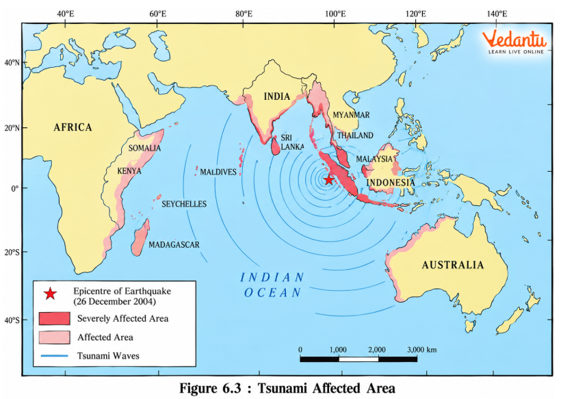
Answer: Tsunamis are long ocean waves produced by a sudden displacement of seawater. The figure helps students understand that tsunamis can affect coastal regions far from the point where the original disturbance occurs.
1. Undersea Earthquakes: Strong undersea earthquakes can suddenly move the seafloor and displace seawater.
2. Volcanic Eruptions: Some underwater or coastal volcanic events can also generate tsunamis.
3. Wave Movement: Tsunami waves travel across the ocean, carrying substantial energy.
4. Deep Ocean Conditions: Their wave height may be comparatively small in deep water, making them difficult to recognise.
5. Shallow Water: As waves approach the coast, they slow down and can increase in height.
6. Coastal Flooding: Large volumes of water may move inland, damaging settlements and infrastructure.
7. Strong Currents: Powerful incoming and outgoing flows can move debris and create additional dangers.
8. Coastal Vulnerability: Low-lying islands, coastal settlements and harbour areas are especially exposed.
9. Warning Systems: Monitoring earthquakes and changes in sea level supports early warnings.
10. Evacuation: Moving people away from exposed coasts and towards safe higher ground can reduce casualties.
11. Public Education: Coastal communities need to understand warning messages and evacuation routes.
12. Indian Ocean Context: The chapter uses tsunami impacts to demonstrate the need for disaster preparedness in coastal and island regions.
Map-Based Questions
(a) Are tsunami effects limited to the coast nearest the earthquake?
Answer: No. Tsunami waves can travel across large distances and affect several coastal regions.
(b) Why are low-lying coastal areas especially vulnerable?
Answer: They can be inundated when tsunami water travels inland.
(c) Why is warning important?
Answer: It gives coastal communities time to evacuate before dangerous waves arrive.
Conclusion: Tsunamis cannot always be prevented, but monitoring, public awareness and timely evacuation can significantly reduce their human impact.
Q22. Explain the atmospheric conditions required for the formation of tropical cyclones. Why are coastal areas of India vulnerable?
Answer: Tropical cyclones are intense low-pressure systems that develop over warm tropical seas.
Conditions for Cyclone Formation
Warm Ocean Water: Warm sea-surface conditions supply moisture and heat to the developing storm.
Moist Air: Rising humid air supports cloud formation and releases latent heat during condensation.
Low-Pressure Disturbance: An initial area of low pressure helps organise the developing system.
Coriolis Force: Earth's rotation helps develop cyclonic circulation. Tropical cyclones rarely form very close to the Equator because the Coriolis effect is weak there.
Atmospheric Instability: Unstable air encourages rising motion and cloud development.
Limited Vertical Wind Shear: Weak differences in wind direction and speed with height favour organised cyclone development.
Why India's Coasts Are Vulnerable
Peninsular Location: India is bordered by the Arabian Sea and Bay of Bengal.
Bay of Bengal Cyclones: October and November are identified as important months for cyclone activity in the Bay of Bengal.
Strong Winds: Severe cyclones can damage houses, trees, electrical systems and transport.
Heavy Rainfall: Intense rain can cause flooding in coastal and nearby inland areas.
Storm Surge: Cyclone winds and pressure conditions can cause a dangerous rise in coastal sea level.
Coastal Settlements: People living near the shoreline may face greater exposure to cyclonic winds and flooding.
Cyclone Conditions and Their Role
Conclusion: Tropical cyclones develop through the interaction of warm oceans and atmospheric circulation. Their coastal impacts make early warnings and evacuation planning important.
Q23. Study Figure 6.4 – Wind and Cyclone Hazard Zones. Explain how geographical location affects India's cyclone vulnerability.
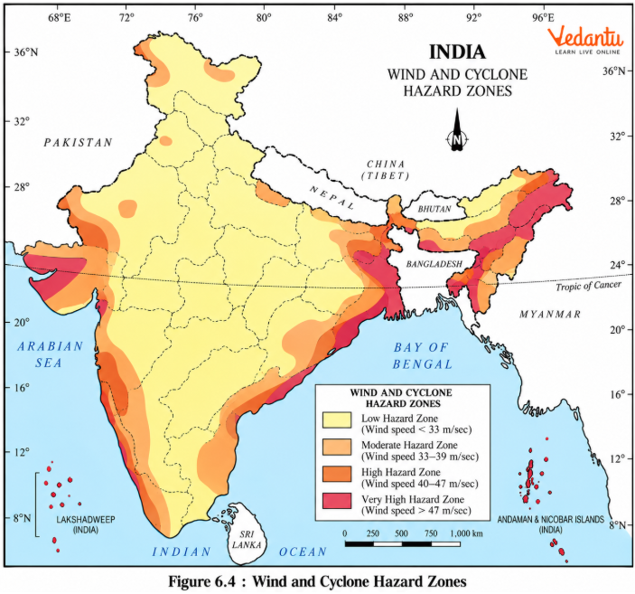
Answer: The map identifies regions exposed to different wind and cyclone hazards. India's vulnerability varies with coastal location, weather systems and population exposure.
1. Bay of Bengal Coast: The eastern coast is exposed to tropical cyclones developing over the Bay of Bengal.
2. Arabian Sea Coast: Western coastal regions may also experience cyclones originating over the Arabian Sea.
3. Delta Regions: Low-lying deltaic regions are vulnerable to strong winds, heavy rainfall and storm surges.
4. Odisha and Andhra Pradesh: These coastal regions are important examples when studying cyclone-related risks.
5. Tamil Nadu: The coast can experience cyclonic disturbances, particularly during the retreating monsoon period.
6. Gujarat: The northwestern coast is also exposed to Arabian Sea cyclones.
7. Coastal Settlements: Dense populations and infrastructure near the sea increase potential damage.
8. Inland Weakening: Tropical cyclones generally lose strength after moving inland because their supply of energy from warm ocean water decreases.
9. Different Hazard Levels: Map zones indicate relative hazard conditions and should be interpreted using the original legend.
10. Disaster Planning: Hazard maps can inform building design, emergency shelter locations and evacuation planning.
Map-Based Questions
(a) Name two coastal regions exposed to cyclone hazards.
Answer: Odisha and Andhra Pradesh.
(b) Can the Arabian Sea produce tropical cyclones?
Answer: Yes. Tropical cyclones develop over both the Arabian Sea and the Bay of Bengal.
(c) Why should low-lying coastal settlements pay attention to storm surges?
Answer: Storm surges can cause seawater to inundate populated areas and agricultural fields.
(d) How can this map be used for disaster preparedness?
Answer: It helps identify areas where cyclone-resistant infrastructure, emergency shelters and evacuation planning are especially important.
Conclusion: Cyclone risk depends on both the geographical occurrence of storms and the vulnerability of exposed coastal communities.
Q24. Study Figure 6.6 – Flood Hazard Zones. Why are floods frequent in the Brahmaputra and Ganga basins, and how can their impacts be reduced?
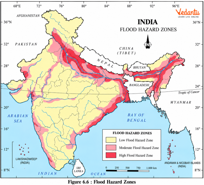
Answer: Floods occur when water spreads beyond the normal capacity of rivers or drainage channels and inundates surrounding land.
Causes of Flooding
Heavy Monsoon Rainfall: Intense seasonal rainfall increases river discharge.
Himalayan Tributaries: Rivers receive water from extensive mountain catchments.
Low-Lying Plains: The Brahmaputra and Ganga plains contain floodplains where water can spread during high discharge.
Sediment Deposition: River sediments can affect channel capacity and flow patterns.
Blocked Drainage: Human activities may obstruct streams and natural drainage channels.
Floodplain Encroachment: Settlements and infrastructure in flood-prone areas face greater losses.
Important Flood-Prone Regions
Assam: The Brahmaputra and its tributaries contribute to recurring floods.
Bihar: Himalayan river systems and monsoon discharge are important factors.
West Bengal: River flooding and coastal hazards affect different parts of the state.
Eastern Uttar Pradesh: Several Ganga tributaries can flood the plains.
Western India: Flash flooding can affect parts of Rajasthan and Gujarat after heavy rainfall.
Tamil Nadu: Some floods occur during November–January in association with retreating monsoon rainfall.
Consequences
Floods damage crops, houses, roads, railways and bridges.
They can displace people and livestock.
Contaminated water may contribute to disease outbreaks.
Floodwater can deposit fertile alluvial silt, although this limited benefit does not outweigh the major losses from destructive flooding.
Flood-Control Measures
Improve embankments and other appropriate flood-protection infrastructure.
Protect river channels and avoid unsuitable construction on floodplains.
Use watershed conservation and afforestation where suitable.
Strengthen warnings, preparedness and evacuation arrangements.
Map-Based Questions
(a) Which northeastern state is especially associated with Brahmaputra flooding?
Answer: Assam.
(b) Name two states in the Ganga basin that experience recurring floods.
Answer: Bihar and eastern Uttar Pradesh.
(c) Why might Rajasthan experience a flash flood despite its generally dry climate?
Answer: A short spell of intense rainfall can produce rapid runoff, particularly where natural drainage is obstructed.
(d) Why are floodplain settlements vulnerable?
Answer: Floodplains are natural areas where rivers spread during high discharge. Buildings located there are directly exposed to inundation.
Conclusion: Flood management requires understanding river behaviour together with land use, settlement patterns and regional rainfall.
Q25. Study Figure 6.7 – Drought Prone Areas. Explain the distribution of extreme, severe and moderate drought-prone regions in India.
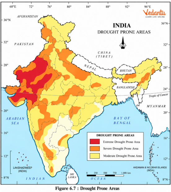
Answer: Drought vulnerability is not evenly distributed across India. It depends on rainfall, evaporation, water availability, agricultural practices and local environmental conditions. Drought-prone regions are classified according to their severity.
1. Extreme Drought-Affected Areas
These include much of western Rajasthan, especially the Marusthali region, and the Kachchh region of Gujarat.
2. Jaisalmer and Barmer
These districts are identified as important examples of extreme drought-affected parts of the Indian desert.
3. Severe Drought-Prone Areas
These include parts of eastern Rajasthan, Madhya Pradesh, eastern Maharashtra and the interior Peninsular region.
4. Karnataka Plateau
Interior parts of the Karnataka Plateau are included among the severely drought-prone areas described in the chapter.
5. Interior Tamil Nadu
Northern parts of interior Tamil Nadu also experience significant drought vulnerability.
6. Other Interior Regions
Parts of Jharkhand and interior Odisha are listed among the severe drought-prone areas.
7. Moderate Drought-Affected Areas
These include parts of Haryana, southern Uttar Pradesh, Gujarat, Maharashtra outside Konkan, and interior Karnataka.
8. Monsoon Dependence
Rainfall variability is an important reason for repeated droughts in many regions.
9. Evaporation
High temperatures and evaporation can intensify shortages of available water.
10. Water Demand
Heavy withdrawal of water from reservoirs and groundwater sources can worsen drought conditions.
Drought-Prone Regions in India
Map-Based Questions
(a) Which part of Rajasthan is especially drought-prone?
Answer: Western Rajasthan, particularly the Marusthali region.
(b) Which part of Gujarat is identified as extremely drought-affected?
Answer: Kachchh.
(c) Why can drought affect agricultural areas receiving seasonal rainfall?
Answer: Rainfall may be insufficient, delayed or unevenly distributed, reducing soil moisture during important stages of crop growth.
(d) Can one part of India experience drought while another faces floods?
Answer: Yes. India's monsoon rainfall varies considerably between regions and seasons.
Conclusion: Drought-prone maps help identify where water conservation, irrigation planning and drought-resistant farming practices are especially important.
Q26. Explain the social, economic and environmental consequences of drought. What immediate and long-term measures can reduce drought impacts?
Answer: Drought can affect crops, water supply, livestock, ecosystems and human health. Its consequences may continue even after rainfall returns.
Major Consequences
Crop Failure: Insufficient soil moisture can damage crops and reduce agricultural production.
Food Shortage: Widespread crop failure may create shortages of food grains, known as akal.
Fodder Shortage: Dry conditions can reduce available fodder for livestock.
Water Scarcity: Rivers, reservoirs and groundwater sources may become inadequate.
Livestock Loss: Cattle and other animals may suffer from shortage of feed and drinking water.
Migration: People and livestock may move to other areas in search of work, food or water.
Health Problems: Use of unsafe water can contribute to waterborne diseases.
Environmental Damage: Water shortages can weaken vegetation and disrupt ecosystems.
Traditional expressions include akal for food scarcity, trinkal for fodder scarcity and jalkal for water scarcity. A combination of all three shortages is described as trikal.
Immediate Mitigation Measures
Provide safe drinking water and essential medicines.
Arrange fodder and drinking water for livestock.
Provide emergency relief and support temporary relocation where necessary.
Long-Term Mitigation Measures
Rainwater Harvesting: Collect and store rainfall for later use.
Groundwater Assessment: Identify and manage aquifers.
Water Storage: Plan reservoirs and storage systems where suitable.
Drought-Resistant Crops: Encourage crops suited to areas with limited rainfall.
Agricultural Training: Help farmers adopt appropriate water-use and cultivation practices.
Remote Sensing: Use satellite information to study water availability and drought-prone conditions.
Careful Water Planning: Evaluate proposals for transferring water between river basins while considering feasibility and environmental impacts.
Drought Problems and Responses
Conclusion: Drought management must address urgent needs while also improving long-term water security and agricultural resilience.
Q27. Explain why landslides are common in the Himalayas, northeastern hills and parts of the Western Ghats. Suggest measures to reduce landslide disasters.
Answer: Landslides involve the rapid movement of rock, soil or debris down a slope. Their occurrence depends strongly on local geological, climatic and land-use conditions.
Causes of Landslides
Steep Slopes: Gravity acts more strongly on loose material on steep terrain.
Unstable Rocks: Fractured or weak geological structures may fail.
Heavy Rainfall: Rainwater can saturate slopes and reduce stability.
Earthquakes: Strong shaking can trigger rockfalls and slope failures.
Deforestation: Removal of vegetation can reduce the natural reinforcement of soil.
Road Construction: Slope cutting may disturb the stability of hillside terrain.
Mining: Excavation and subsidence may contribute to local slope failures.
Important Vulnerable Regions
Himalayas: Young, steep and tectonically active mountain regions.
Northeastern Hills: Heavy rainfall and difficult terrain increase vulnerability.
Western Ghats and Nilgiris: Steep slopes and heavy seasonal rainfall create landslide-prone conditions.
Andaman and Nicobar Islands: Some unstable and tectonically active areas are vulnerable.
Mining Regions: Local landslides or subsidence may occur in parts of Peninsular India.
Consequences
Landslides may block mountain roads and railway routes.
Debris can damage houses and other infrastructure.
River blockages may create additional flood risks.
Disruption of transport can affect supplies, tourism and other economic activities.
Mitigation Measures
Restrict unsuitable construction on highly unstable slopes.
Use careful geological and slope assessments before building roads and dams.
Encourage afforestation and appropriate vegetation protection.
Improve surface drainage to reduce water accumulation.
Support suitable terrace farming and soil-conservation practices.
Prepare area-specific landslide vulnerability maps and response plans.
Comparison of Landslide Vulnerability
Conclusion: Landslide mitigation is most effective when it addresses the specific slope, geological, rainfall and human-activity conditions of each region.
Q28. Explain the three stages of disaster management covered in the chapter. How can preparedness reduce losses from earthquakes, floods, cyclones and landslides?
Answer: Disaster management involves organised action before, during and after a disaster. Three main stages are identified.
Part A: Pre-Disaster Management
Hazard Identification: Identify possible disasters in a particular region.
Vulnerability Mapping: Prepare maps showing areas and communities at greater risk.
Monitoring: Observe relevant weather, geological and environmental conditions.
Early Warning: Communicate reliable information when warnings are possible.
Preparedness: Develop evacuation routes, emergency plans and public awareness programmes.
Safer Construction: Encourage building designs appropriate for the local hazard.
Part B: During-Disaster Management
Rescue Operations: Assist people facing immediate danger.
Evacuation: Move exposed communities to safer locations when appropriate.
Emergency Shelters: Provide suitable temporary accommodation.
Food and Water: Ensure access to essential supplies.
Medical Support: Provide first aid, emergency treatment and other health services.
Communication: Share accurate information and coordinate response activities.
Part C: Post-Disaster Management
Rehabilitation: Support people who have lost homes, income or essential services.
Infrastructure Recovery: Repair roads, water supply systems, communications and other damaged facilities.
Livelihood Support: Help affected communities resume agricultural and economic activities.
Reconstruction: Rebuild using safer planning and design principles.
Capacity Building: Improve preparedness for future disasters.
Review and Learning: Examine what happened and how future losses can be reduced.
Three Stages of Disaster Management
Application to Different Disasters
Earthquakes: Preparedness focuses on safer buildings and emergency response because earthquakes cannot presently be predicted precisely.
Cyclones: Forecasting and warnings can support evacuation before landfall.
Floods: Monitoring river levels and avoiding unsafe floodplain development can reduce losses.
Landslides: Slope assessment, land-use restrictions and drainage management can help reduce risk.
Conclusion: Disaster management is not limited to rescue after an event. Preparedness, mitigation, immediate response and long-term recovery all help reduce its effects.
Why Practise Class 11 Geography Chapter 6 Important Questions with Vedantu?
Vedantu's Natural Hazards and Disasters Important Questions help students revise India's disaster-prone regions, causes of major hazards and methods of disaster management through detailed answers and map practice.
How to Prepare Class 11 Geography Chapter 6 Important Questions?
Understand the differences: Revise natural hazards, disasters and vulnerability.
Compare major disasters: Learn the causes and effects of earthquakes, cyclones, floods, droughts and landslides.
Practise hazard maps: Focus on Figures 6.2, 6.4, 6.6 and 6.7.
Revise mitigation measures: Connect each hazard with suitable disaster-management responses.
Use regional examples: Remember the Himalayas, Assam, Bihar, coastal Odisha, western Rajasthan and the Western Ghats.
Important Study Material Links for Class 11 Geography Chapter 6
Students can use the following resources to revise natural hazards, their geographical distribution and disaster-management measures.
CBSE Class 11 Geography Other Books Important Questions and Study Resources
Chapter-Wise Important Questions for Class 11 Geography – India: Physical Environment
Students can also practise other chapters of India: Physical Environment to connect India's physical geography, climate, vegetation and drainage with the natural hazards experienced in different regions.
Important Study Materials for Class 11 Geography
FAQs on Important Questions and Answers for Class 11 Geography Chapter 6 – Natural Hazards and Disasters (India: Physical Environment) | 2026-27
1. Why do different regions of India experience different types of natural disasters?
India's geographical conditions vary from one region to another. The Himalayas are vulnerable to earthquakes and landslides because of tectonic activity and steep slopes. Assam and Bihar experience floods due to heavy monsoon rainfall and large river systems, while western Rajasthan faces drought because of low and irregular rainfall. Coastal regions are exposed to cyclones and tsunamis. These differences show how climate, relief and geological conditions influence natural hazards across India.
2. What is the difference between a natural hazard and a natural disaster?
A natural hazard is an event or condition that may cause harm. It becomes a disaster when it causes serious damage, loss of life or disruption that exceeds a community's normal ability to cope. For example, heavy rainfall is a hazard, but widespread flooding that destroys homes and disrupts essential services can become a disaster.
3. Why are earthquakes more frequent in the Himalayas and northeastern India?
These regions are influenced by ongoing tectonic activity associated with the Indian and Eurasian plates and adjoining tectonic structures. Accumulated stress is sometimes released suddenly, producing earthquakes. The steep terrain can also increase the risk of earthquake-triggered landslides.
4. Which hazard maps should students practise for Class 11 Geography India Physical Environment Chapter 6 Important Questions?
Students should focus on Figure 6.2 for earthquake hazard zones, Figure 6.4 for wind and cyclone hazard zones, Figure 6.6 for flood hazard zones, and Figure 6.7 for drought-prone areas. They should learn the regions shown and explain the geographical reasons behind their vulnerability.
5. Why can a tsunami cause serious damage near the coast even when it is hardly noticeable in the deep ocean?
Tsunamis have long wavelengths and may have relatively low wave heights in deep water. As they approach shallow coastal areas, they slow down, and their height can increase. Powerful waves and currents can then flood coastal settlements and damage infrastructure.
6. Why are coastal regions of Odisha, Andhra Pradesh and Tamil Nadu vulnerable to tropical cyclones?
These regions face cyclonic systems developing over the Bay of Bengal. Cyclones can bring strong winds, intense rainfall and storm surges. Low-lying coastal settlements and delta regions may experience flooding and significant infrastructure damage.
7. Why does Assam experience frequent floods while western Rajasthan is generally drought-prone?
Assam receives heavy monsoon rainfall and is drained by the Brahmaputra and its tributaries, which can overflow onto floodplains. Western Rajasthan receives much less rainfall and faces high water scarcity. However, intense rainfall can occasionally produce flash floods even in dry regions.
8. What are the four types of drought explained in Class 11 Geography Chapter 6?
The four types are meteorological, agricultural, hydrological and ecological drought. They refer respectively to insufficient rainfall, inadequate soil moisture for crops, reduced water availability in rivers or storage systems, and damage to natural ecosystems caused by water shortage.
9. How do deforestation and road construction increase the risk of landslides?
Trees help stabilise slopes, while road construction may involve cutting into hillsides. Removing vegetation and disturbing the natural slope can increase instability, especially during heavy rainfall or earthquakes. This is why construction and land-use planning are important in landslide-prone regions.
10. What are the three stages of disaster management, and why are they important?
The stages are pre-disaster management, disaster response, and post-disaster recovery. They include preparedness and risk reduction, rescue and relief, and rehabilitation and reconstruction. Working across all three stages can help reduce losses and improve future preparedness.
11. Are Class 11 Geography Chapter 6 Natural Hazards and Disasters Question Answers useful for map-based exams?
Yes. The practice set includes questions based on India's earthquake, cyclone, flood and drought hazard maps. Students can revise important regions, identify geographical patterns and explain why one area is more vulnerable to a particular hazard than another.
12. How can I prepare long answers on natural hazards and disaster management without memorising every paragraph?
Use a consistent structure: meaning, causes, geographical distribution, consequences and mitigation. For example, an earthquake answer can explain plate movements, vulnerable regions, damage to buildings and roads, and earthquake-resistant construction. Use relevant hazard maps and regional examples to support the explanation.