


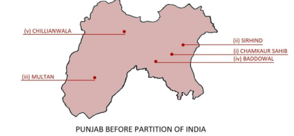
Fill in the map of Punjab (Before 1947 A.D.)
i) Chamkaur Sahib
ii) Sirhind
iii) Multan
iv) Baddowal
v) Chillianwala
Answer
516.9k+ views
Hint:
- The first step in drawing a map is to draw a rough outline and then we should proceed to add details in the borders.
- Appropriate colours and symbols should be used to label the desired locations on the map.
- For this question specifically, we must also know where the given places are located in the present day.
Complete answer:
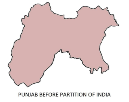
Punjab is a northern Indian state. The state is bordered to the north by the Indian union territories of Jammu and Kashmir, Chandigarh to the east, Himachal Pradesh to the north and northeast, Haryana to the south and Rajasthan to its southwest. It is part of the broader Punjab region of the Indian subcontinent.
Chamkaur Sahib is a sub-divisional town in the district of Rupnagar in Punjab, India. It is known for the Mughals' First and Second Battles of Chamkaur (1702) and Guru Gobind Singh's Second Battle of Chamkaur (1704).
Fatehgarh Sahib was previously known as Sirhind. It can be found on the Delhi-Lahore Highway. It has a population of 60,851 people. Fatehgarh Sahib is the name of the district in Punjab where it is now the district headquarters.
Multan is the capital of the Multan Division in Pakistan's Punjab province. Multan, Pakistan's 7th largest city and the main cultural and economic centre of southern Punjab, is located on the Chenab River's side.
Chillianwala is a village and union council in Pakistan's Punjab province's Mandi Bahauddin District. It is located to the northeast of Mandi Bahauddin, the district capital. The most prominent feature in the village's centre is two graveyards, both of which are highly revered by residents of Chillianwala, Mojianwala, and the surrounding towns and villages.
Baddow is a village in the Gurdaspur district of Punjab, India, located in Batala. Sarpanch, the village's elected official, is in charge of administration.
Note: Over time, the geographical meaning of the word "Punjab" has shifted. It applied to a relatively small region between the Indus and the Sutlej rivers during the Mughal Empire's 16th-century reign. Until 1947, the Punjab Province in British India included the present-day Indian states and union territories of Punjab, Haryana, Himachal Pradesh, Chandigarh, and Delhi, as well as the present-day areas of Pakistan.
- The first step in drawing a map is to draw a rough outline and then we should proceed to add details in the borders.
- Appropriate colours and symbols should be used to label the desired locations on the map.
- For this question specifically, we must also know where the given places are located in the present day.
Complete answer:
Punjab is a northern Indian state. The state is bordered to the north by the Indian union territories of Jammu and Kashmir, Chandigarh to the east, Himachal Pradesh to the north and northeast, Haryana to the south and Rajasthan to its southwest. It is part of the broader Punjab region of the Indian subcontinent.
Chamkaur Sahib is a sub-divisional town in the district of Rupnagar in Punjab, India. It is known for the Mughals' First and Second Battles of Chamkaur (1702) and Guru Gobind Singh's Second Battle of Chamkaur (1704).
Fatehgarh Sahib was previously known as Sirhind. It can be found on the Delhi-Lahore Highway. It has a population of 60,851 people. Fatehgarh Sahib is the name of the district in Punjab where it is now the district headquarters.
Multan is the capital of the Multan Division in Pakistan's Punjab province. Multan, Pakistan's 7th largest city and the main cultural and economic centre of southern Punjab, is located on the Chenab River's side.
Chillianwala is a village and union council in Pakistan's Punjab province's Mandi Bahauddin District. It is located to the northeast of Mandi Bahauddin, the district capital. The most prominent feature in the village's centre is two graveyards, both of which are highly revered by residents of Chillianwala, Mojianwala, and the surrounding towns and villages.
Baddow is a village in the Gurdaspur district of Punjab, India, located in Batala. Sarpanch, the village's elected official, is in charge of administration.
Note: Over time, the geographical meaning of the word "Punjab" has shifted. It applied to a relatively small region between the Indus and the Sutlej rivers during the Mughal Empire's 16th-century reign. Until 1947, the Punjab Province in British India included the present-day Indian states and union territories of Punjab, Haryana, Himachal Pradesh, Chandigarh, and Delhi, as well as the present-day areas of Pakistan.
Recently Updated Pages
Master Class 11 English: Engaging Questions & Answers for Success
Master Class 11 Maths: Engaging Questions & Answers for Success
Master Class 11 Biology: Engaging Questions & Answers for Success
Master Class 11 Physics: Engaging Questions & Answers for Success
Master Class 11 Accountancy: Engaging Questions & Answers for Success
Class 11 Question and Answer - Your Ultimate Solutions Guide
Trending doubts
There are 720 permutations of the digits 1 2 3 4 5 class 11 maths CBSE
What organs are located on the left side of your body class 11 biology CBSE
Why is 1 molar aqueous solution more concentrated than class 11 chemistry CBSE
SiO2GeO2 SnOand PbOare respectively A acidic amphoteric class 11 chemistry CBSE
Bond order ofO2 O2+ O2 and O22 is in order A O2 langle class 11 chemistry CBSE
What is 1s 2s 2p 3s 3p class 11 chemistry CBSE