


Class 9 Social Science Chapter 1 Important Questions and Answers on Understanding Oceans
The Class 9 Chapter 1 Oceans and Life Important Questions PDF covers ocean-floor features, tides, currents, coastal erosion, tsunami warnings and maritime zones. It includes 1 mark MCQs, 2 mark very short answers, 3 mark short answers and 5 mark long answers with solutions for practice.
Class 9 Social Science Chapter 1 Important Questions MCQ
Q1. Which is the deepest place on Earth?
A) Mid-Ocean Ridge
B) Mariana Trench
C) Mauna Kea
D) Abyssal Plain
Answer: B) Mariana Trench
Q2. A flat-topped underwater mountain, usually an old seamount whose top was worn away and later sank underwater, is called a:
A) Abyssal hill
B) Continental rise
C) Guyot
D) Rift valley
Answer: C) Guyot
Q3. Waves are mainly caused by:
A) Underwater earthquakes
B) The pull of the Moon
C) Differences in salinity
D) Winds blowing across the water
Answer: D) Winds blowing across the water
Q4. What share of the world’s trade (by volume) is carried by sea?
A) 50%
B) 70%
C) 90%
D) 100%
Answer: C) 90%
Q5. Sea ice does not form easily near Norway, even though it is at a high latitude (60°–70°). This is mainly because of the:
A) Labrador Current
B) Gulf Stream
C) Tidal currents
D) Coriolis force
Answer: B) Gulf Stream
Q6. In the tsunami early warning system, Ocean Bottom Pressure Recorders (OBPRs) are used in which stage?
A) Detection
B) Confirmation
C) Tracking
D) Warning Dissemination
Answer: B) Confirmation
Q7. Which of these is a conventional non-living marine energy resource?
A) Biofuels
B) Gas hydrates
C) Natural gas
D) Offshore wind
Answer: C) Natural gas
Q8. The Exclusive Economic Zone (EEZ) extends from the baseline up to:
A) 12 nautical miles
B) 24 nautical miles
C) 100 nautical miles
D) 200 nautical miles
Answer: D) 200 nautical miles
Class 9 Social Science Chapter 1 Very Short Answer Questions
Q9. What is innocent passage? Name one activity it does not allow.
Answer: Innocent passage lets foreign ships pass through a country’s territorial waters as long as they do not threaten its peace, good order or security. Ships must keep moving without stopping, except in emergencies or breakdowns. It does not allow activities such as fishing or military operations.
Q10. Write the full forms of COLREGs and MARPOL.
Answer:
COLREGs: Convention on the International Regulations for Preventing Collisions at Sea.
MARPOL: International Convention for the Prevention of Pollution from Ships.
Q11. What is GEMINI? Who uses it?
Answer: GEMINI (GAGAN-Enabled Mariner’s Instrument for Navigation and Information) is a handheld device made for fishermen. It receives satellite information and sends it to their mobile phones through Bluetooth. This helps keep them safe at sea.
Q12. Why can people reach the Bhadkeshwar Mahadev Temple in Dwarka only during low tide?
Answer: The temple stands on a small hillock in the Arabian Sea. The stone path leading to it is completely underwater during high tide, so that it can be reached only during low tide.
Class 9 Social Science Chapter 1 Short Answer Questions
Q13. Explain how waves turn a headland into a sea stack and a stump.
Answer: Waves are called coastal architects because they shape the shoreline through erosion.
Waves hit the coast and open a large crack in the headland through hydraulic action.
Hydraulic action and abrasion widen the crack into a sea cave.
Erosion at the back of the cave forms a sea arch.
The top of the arch collapses due to gravity, leaving a tall sea stack.
Over time, erosion and weathering reduce the stack to a stump.
Q14. Differentiate between spring tides and neap tides.
Answer:
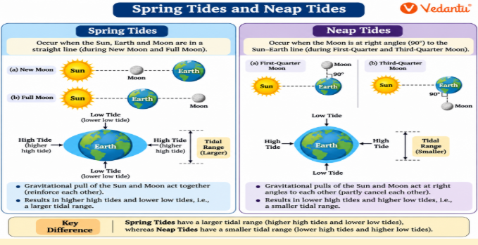
Spring tides: They occur when the Sun, the Earth and the Moon are in a straight line, on full moon and new moon days. The combined pull of the Sun and the Moon causes unusually high high tides and unusually low low tides.
Neap tides: They occur when the Moon is in its first- and third-quarter phases. The Sun's and Moon's pulls act in different directions, so the difference between high and low tide becomes smaller.
Q15. Compare the Gulf Stream and the Labrador Current. Where are fishing grounds found?
Answer:
The Gulf Stream is a warm current that starts in the Gulf of Mexico and flows towards Norway. It keeps Norway’s waters fairly warm, so sea ice does not form easily there.
The Labrador Current is a cold current that flows along Canada's east coast. It carries freezing water and helps form sea ice and icebergs even at lower latitudes.
Fishing grounds are found where warm and cold currents meet. These waters are nutrient-rich and support many kinds of fish.
Q16. What is the Blue Economy? State any four aims of SDG 14 (Life Below Water).
Answer: The World Bank defines Blue Economy as “the sustainable use of ocean resources to promote economic growth, improved livelihoods, and jobs, while preserving the health of the marine ecosystem.”
SDG 14 aims to (any four):
Reduce marine pollution
Protect marine ecosystems
Address ocean acidification
Regulate fishing
Conserve marine areas
Eliminate harmful subsidies
Increase economic benefits
Class 9 Social Science Chapter 1 Long Answer Questions
Q17. Describe the important submarine relief features of the ocean floor.
Answer: Just as land has mountains, valleys and plains, the ocean floor also has landforms. Together, they are called submarine relief or ocean relief. The important features are:
Continental shelf: The shallow, submerged edge of a continent that extends under the ocean. It is rich in marine life and in resources like oil and gas.
Continental slope: The steep slope that marks the continent's true edge.
Abyssal plain: The vast, flat and deep ocean floor.
Mid-Ocean Ridge: A huge underwater mountain range formed by volcanic activity. It is the world’s longest mountain range, hidden beneath the ocean.
Ocean trenches: The deepest parts of the ocean. The Mariana Trench in the Pacific Ocean is the deepest place on Earth.
Seamounts and guyots: Seamounts are underwater mountains, often volcanic, that rise from the ocean floor but do not reach the sea surface. Wave action can flatten some over thousands of years, forming guyots. Some underwater mountains, like Mauna Kea (Hawai’i), are taller than Mount Everest.
Q18. Explain the importance of tides for navigation, fishing and energy.
Answer:
Navigation: High tides raise the water level near the shore so that ships can enter harbours more easily. Tidal ranges in some ports can reach 4–5 metres, and the Gulf of Khambhat has one of the highest, about 12 metres. Before docking, ships must check water depth and tidal range, especially during low tide. In shallow channels like the Singapore Strait, Very Large Crude Carriers (VLCCs) wait for hours and pass only during high tide so they do not run aground.
Tidal currents: Large amounts of water flow in and out of coastal areas with the tides, creating strong currents. These can reach speeds of 5–6 knots (about 9–11 km/h).
Fishing: During high tide, many fish move closer to the shore to find food and shelter. This gives fishing communities a better catch.
Energy: In some places, rising and falling tides generate electricity. India has a coastline of 11,098.81 km. Tidal energy is not yet widely used on a large scale, but the Gulf of Kutch, the Gulf of Khambhat and the Sundarbans are among the major sites identified.
Q19. How do Early Warning Systems protect coastal communities from tsunamis and cyclones? Explain with reference to India.
Answer: Early Warning Systems work like giant alarm systems for coastal areas. They detect cyclones and tsunamis, predict disasters and give timely warnings so that people can move to safety.
The tsunami early warning system has four stages:
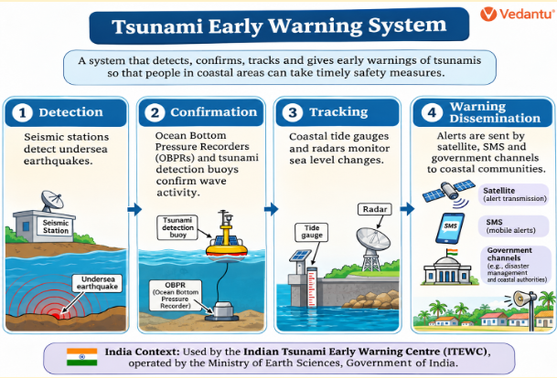
Detection: A network of seismic stations detects undersea earthquakes in real time.
Confirmation: Ocean Bottom Pressure Recorders on the seafloor detect tsunami waves passing by.
Tracking: Coastal tide gauges and radars watch changes in sea level.
Warning dissemination: Alerts are sent by satellite to government agencies, and by SMS and other channels to officials and the public.
The scale of the 2004 Indian Ocean Tsunami led many countries to set up tsunami early warning systems. Under an initiative of the Indian Tsunami Early Warning Centre (ITEWC), the Government of India set up a real-time network of tsunami detection buoys. ITEWC sends alerts to the Government of India, which informs state governments and emergency response teams.
For cyclones, India has Cyclone Warning Services and Marine Weather Services that monitor storms along both the eastern and western coasts. The National Cyclone Risk Mitigation Project (NCRMP) builds cyclone shelters, strengthens warning systems and improves emergency response. INCOIS, along with the IMD, has set up the Storm Surge Early Warning System (SSEWS) to forecast storm surges and cyclone-driven coastal flooding.
Fishermen get alerts in their local language on their mobile phones through the GEMINI device.
Public awareness and training are also important, so that officials and coastal communities know how to respond when a warning is issued.
Q20. Explain the different maritime zones. Why are international maritime rules important?
Answer:
Territorial waters: The sea area closest to a country. The country has near-complete control here, subject to the right of innocent passage for foreign ships. It can make laws on customs, immigration and pollution control. As shown in Fig. 1.20, it extends up to 12 nautical miles from the baseline.
Contiguous zone: Extends from the baseline up to 24 nautical miles. The country has limited control over customs, fiscal matters and illegal immigration.
Exclusive Economic Zone (EEZ): Extends up to 200 nautical miles from the baseline and is defined under UNCLOS. The country has special rights to use resources such as fish, oil and gas. However, it does not fully own or control the waters, and ships of other countries may still pass peacefully.
High seas: The area beyond all EEZs, covering about 64 per cent of the world’s oceans. They belong to no one country and are part of the global commons. All countries have equal rights to sail, fish, fly over them, lay undersea cables, build lawful structures such as artificial islands, and explore for minerals. Problems like overfishing, illegal fishing and conflicts over resources arise here. Flag-state laws (the country where a ship is registered) apply.
Why maritime rules matter: They keep the oceans safe and ensure resources are used fairly and sustainably. COLREGs help prevent collisions, and MARPOL reduces ship pollution. Without such rules, the oceans could become dangerous and chaotic, with more pollution, accidents and disputes. Common standards for all ships keep the oceans safe, clean and open for trade and travel.
Key Topics to Study for Class 9 Social Science Chapter 1 Oceans and Life
Before practising the important questions, review these chapter topics to understand ocean features, movements, resources, and safety measures.
Prepare for Your Exams with Class 9 Oceans and Life Important Questions by Vedantu
Vedantu's solved questions help students understand key topics through clear questions and answers. Students can use these questions to practise the following topics:
Identify ocean features: Solved questions help students distinguish ocean trenches, ridges, continental shelves and seamounts.
Compare key concepts: Practise questions on spring tides and neap tides, warm currents and cold currents.
Understand coastal processes: Learn how cracks develop into caves, arches, stacks and stumps through wave erosion.
Revise tsunami safety: Understand the four stages of tsunami warnings and how alerts reach coastal communities.
Improve answer writing: Use Vedantu's solved answers to check important facts, correct mistakes and write clear responses.
Important Study Material Links for Class 9 Social Science Part 2 Chapter 1
Class 9 Social Science Chapter-Wise Important Questions
Important Study Materials for CBSE Class 9 Social Science
FAQs on Important Questions and Answers 2026-27 for Class 9 Social Science (Understanding Society: India and Beyond – Part II) Chapter 1 Oceans and Life
1. What are the most important topics in Class 9 Social Science Chapter 1: Oceans and Life?
Important topics include ocean floor features, waves, tides, ocean currents, marine resources, the Blue Economy, tsunami warning systems, and maritime zones. Students should also understand how oceans affect climate and human activities.
2. What is the difference between a continental shelf and a continental slope?
The continental shelf is the shallow, submerged extension of a continent. The continental slope is the steep area that connects the continental shelf to the deep ocean floor.
3. Why are spring tides higher than neap tides?
Spring tides occur during the new moon and full moon when the Sun, Moon and Earth are aligned. Their combined gravitational pull produces a greater tidal range. Neap tides occur during the first and third quarters of the Moon, when the tidal range is smaller.
4. How do ocean currents affect climate and fishing?
Warm ocean currents raise temperatures along nearby coasts, while cold currents can lower them. Where warm and cold currents meet, nutrient-rich waters often support large fish populations, making these areas important fishing grounds.
5. What is the Exclusive Economic Zone (EEZ) in Oceans and Life Chapter 1?
The Exclusive Economic Zone extends up to 200 nautical miles from a country's baseline. Within this zone, the country has special rights to explore, manage and use marine resources such as fish, oil and natural gas.
6. How does Vedantu help students prepare for Class 9 Oceans and Life important questions and answers?
Vedantu provides chapter-wise important questions and answers, including MCQs, short answers, and long answers. Students can use these questions alongside revision notes and NCERT Solutions to practise key concepts, check their understanding and prepare for school exams.